Crowding Factor
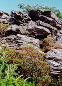
So many climbing opportunities exist near the Linville Gorge! Exploring these rocky crags and pinnacles with helmet, rope and karabiner is a righteous experience. Something inspiring and beyond words awaits one among these precipices and ancient mineral cliffs. And each person may come away with a different inspiration. Some will thrill to the challenge of Class V routes, pushing their own limits and perhaps the limits of the sport. Others may enjoy reconnoitering graceful rock shapes and structures, or of exploring the possibilities of just moving over rock, on rope and off, in less challenging and less dangerous circumstances. The Table Rock summit trail meanders higher over eroded roots, past water seeps, around fallen boulders, and rhododendron branches. Suddenly, granite slabs and layered rock angle up 40 degrees toward a hot azure high cirrus sky. These rocks are punctuated with crevices filled with soil and blueberry bushes.
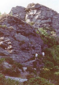
Scrambling up the rocks brings one to a pine tree species who's cone holds tightly to its seeds until relaxed by fire. A chaotic stair case of gray boulders and quartz-embedded ledges stretches off toward the summit. Ravens call and soar on swirls of mountain morning wind. A rope is fixed around an eight inch pine with a bowline and 2 half hitches. A figure 8 descender, and prussic safety, lets one work down among lichen flecked stone faces to see multi-colored fruiting bodies and a cathedral of small fungus shapes. To peer at cliff layers and wonder what kept a particular rock from being eroded into sand and mixed with organic decay to make soil like that of the walkway below. Tiny yellow and gray birds perch off to the right and chatter distinctively, watching the cliff expanse for food and danger. Moving about here on this rope is a symphony of combination moves related to hanging from or being supported by the rope, alternating with balanced off-rope steps. At times a crack or crevice will need a chock stone to position the rope for descent without lateral pull. Climbing back up without using the rope for support is a usually-possible game to play with oneself, sliding the prussic up as one ascends.
Did a climber die here? Quotations come to mind:
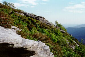
Natahala Outdoor Center climbing instructor:- "Climbing is more a mind thing than a strength thing." She added " Argue for your limitations and, sure enough, they are yours." Hours of such exploring make tea and lunch appealing. A bird soars out over the gorge, looking like a falcon, while amber tea is sipped and black-brown bread is munched. Far across are the cliffs called "Wiseman's View". Wandering south on the Mountains to the Sea Trail is a route called "The Humbler". That climb is in use by a crowd of repellers, but a nearby circuitous and rambling descent begs for exploration. There is 50? foot cliff which the repellers descend vertically in one jump. The route in question makes the same ascent in 3 more-or-less 45 degree pitches. Near the bottom is a rock fall jumble reaching up 25 feet. Then there are several feet of cliff side, snake-harbouring? crevices that could be worked around to the base of the descending platform leaning down from the top. The crowd cheering from below the repellers coming down has me wanting to go up top to begin reconnaissance. My trail becomes a tunnel through rhododendrons that soon opens out onto sunny open rock. Beyond a blackened charcoal fire pit where climbers have camped, there are large steel rings embedded in the rocks, just above the rock jumble below. Tying into those rings doesn't allow an easy descent of the upper platform. A sling of 1 inch webbing around a large rhododendron bush makes the rope angle better. The bright blue morning sky has turned leaden and the smell of rain is on the wind. Having no rain jacket suggests a wet afternoon. The upper platform angles down 20 feet while arcing 30 feet to the west. Textures of slabs and boulders, the white erosion sand, against the green blueberry leaves captivate the imagination! Descending to the base of the upper platform goes easily. If there turns out to be a place that won't allow up-climbing, one can just descend to the cliff base. The ledge near the next descent, down to the rock jumble, goes around a blind corner not seen from below, however. A need to place good protection is met by finding no more slings or chocks. This is Class V stuff to avoid climbing for now.
*** Scrambles Amongst The Alps - Edward Whymper available from Mountain Books © 1996 Ikhaya Design Studio " " to Contents |